Retirement - - - - the Final Frontier.

These are the voyages of the Blue Bus.
Its continuing mission: to explore strange, new worlds, to seek out new life and new civilizations, to boldly go where we’ve never gone before.
This trip was five days and four nights. Drive time: 30 hours and 44 minutes. Total miles: 1237. Each leg of the trip was kept short to allow lots of time for sightseeing. Shortest leg: 194 miles. Longest leg: 242 miles.
Four mountain passes; highest: Wolf Creek, 10,856 ft. Three National Parks and one National Monument served as stops along our way. We drove by four different ski resorts, some abandoned for the summer and some serving warm weather visitors too.

I had planned a great circle route around the western half of Colorado, traveling clockwise from Longmont, south to Colorado Springs, then west to the four corners region, Mesa Verde, north up to Grand Junction, then further north returning on U.S. 40. Along the way would be national parks, mountains, passes, rivers, trees, wildfires, and enough scenery to write four travelogue books.
Man has followed where nature led. Many of these river canyons now serve as highways through the mountains. Rivers: Arkansas, San Juan, Rio Grande, Animus, Mancos, Uncampahgre, Gunnison, Delores, Yampa, North Platte, and the Cache la Poudre.
We started Tuesday morning headed south on I-25, through Denver, and down to Colorado Springs. The Springs is one of our favorite vacation destinations: the Garden of the Gods, Manitou Springs, the Pike’s Peak Cog Railroad, Seven Falls, Cave of the Winds, even a reconstructed cave dwelling … We’ve had family reunions along the Fountain Creek, visiting with friends, ice skating, and swimming in the hotel pool. All are great memories, and we’ve haunted this town for most of our married lives.

So it was with great sadness that we saw the large wildfires as we approached the city. Just east of the Air Force Academy we watched planes staging for slurry drops on the visible flames just to the west. Our plan was to drive up US 24 to Woodland Park, one of our favorite routes into the high country. However the fire had forced closure of route 24 just west of Manitou. That forced us to an alternative route. We took CO 115 past Fort Carson and down to Cañon City. There we followed the Arkansas River past Royal Gorge and through the Arkansas canyon to Salida for our first night’s stay.
We learned later that only an hour or two after our passing, I-25 was closed near the Air Force Academy due to smoke and ash and the rush of evacuees fleeing the exploding fire. The devastation to man-made and natural structures is sad, but it is a warning of how the climate in the west is changing, and wildfires will likely become more dangerous and devastating with each passing year. Along much of our journey we counted dead trees at a ratio of one in three due to beetle kill. This is just kindling for the next spark or match.

“Salida” means entrance/exit in Spanish and is an appropriate name for this city at the entrance to the Arkansas River canyons. Salida, Colorado, is known as the “Heart of the Rockies” and is the Chaffee County seat. The city anchors the Upper Arkansas River Valley in central Colorado. Although flanked by majestic 14,000-foot snow capped peaks, at just over 7,000 feet in elevation, Salida enjoys a surprisingly mild climate that some refer to as the Banana Belt. At least that’s what the chamber of commerce says. It is a beautiful little town and like many in Colorado, makes much of its living off tourists and fly fishing.
The town, like numerous Colorado communities of the period, was a creation of the railroad company and its associates. Unlike many other Colorado towns, however, Salida remained essentially a creature of the Denver & Rio Grande. While other industries, the usual mix of mining, quarrying, smelting, agriculture and retail trade—along with the usual ‘related’ trades of salooning, gambling and prostitution—were practiced at various times and magnitudes in Salida, it was the railroad that defined the community. We hope to return some day and ride the train from Salida to Royal Gorge following a slightly different path than the roadway.

I arose early the next morning, before 5 AM. Linda was still asleep, so I went out for a walk. The temperature was a nippy 50 degrees, and I quickly returned for my hoody. I walked a couple of miles up the highway and ended at the big Wal-Mart before turning around and returning to wake Linda and prepare for the day.
We had a nice cold breakfast at the hotel, mixed with juice and hot coffee. We then loaded up for day two of our adventure. However, we didn’t get far as the GPS failed to boot up. It just hung at the start screen. I had purchased this GPS just one year earlier when another satellite navigator failed on the second day of our family trip to Texas. So that was two TomTom GPS boxes failing in one year.

We returned to the Wal-Mart and purchased a Garmin. As judge Milian on People’s Court says so often, “The cheap turns out expensive.” When our first TomTom failed last year, we switched to software on my iPad. That worked well with Linda’s brother Chuck doing the navigating, but the iPad X-Motion app wasn’t really a good GPS solution for me. It was too information rich to glance at while driving, and didn’t fit on the dash. It worked well with a co-pilot assisting, but Linda didn’t really fit that technical role. The iPad app did, however, report on altitude. I found that very interesting, especially when touring the vertical geography of Colorado, and I had often mentioned to Linda how I wish our GPS could do that.

Soon we had the new Garmin GPS installed on the windshield and were headed for Mesa Verde. As I explored the interface on the new navigation tool, I quickly learned it had an “elevation” display. So the rest of the trip I would tell Linda, “now we’re at 7500 feet” or “we’re just over 9,000 feet.” So far I’m very happy with the Garmin, and I don’t recommend TomTom products to my friends any more. Garmin may cost a little more, but I’ve concluded that it is well worth it.
From Salida we traveled up and over the continental divide, crossing at Wolf Creek Pass, a 10,856-foot elevation and home to the small Wolf Creek Ski Area. The view from the top of the pass is awesome as you reckon over the snaking West Fork of the San Juan River. We continued down, past Chimney Rock, to the beautiful city of Durango. A stop for lunch in one of Durango’s shady parks, and we were off to Mancos.

There were several tiny fires on the hillside at Mancos and we spoke to some Forest Service firefighters at a little gas station. The fires were on too steep of a hillside for access, and they were watching them in hopes they would quickly burn out. If not, they planned to request a helicopter water drop. The morning news had warned of three large fires in the area and the sky was not the usual Colorado blue due to clouds and smoke. We continued on to the entrance of Mesa Verde and began our climb to the 7,000-foot elevation of the mesa and our rest for the next two nights at the Far View Inn in the park. Upon leaving the park two days later, we could see smoke from nearby Mancos, and I conclude the first had not gone out. During our drive we saw several helicopters dipping water out of rivers and rushing to two different fires we saw along the way.

After checking in at the Far View Inn in Mesa Verde and the obligatory visit to the gift shop, we went to the Metate Room for some fine dining. Their Corn Chowder with a southwestern flair and spice was delicious. Corn Chowder is my favorite soup, and I always sample it when offered. I enjoyed a stuffed chicken breast entrée with spicy mashed potatoes and vegetables, and I quickly became as stuffed as the namesake meal, and had to decline any desert. My petite dining partner settled for just an appetizer. It was elegant dining at its best and their wine list was very complete, although mostly California vintages and I have become a fan of Oregon wines. Still the Riesling was both sparking and cool on the hot and dusty plateau.
We purchased tickets for two guided tours … inexpensive ($3 per) and the only way to see some of the best cliff dwellings. The next morning, after a simple breakfast at the Terrace Café we headed toward Chapin Mesa, a 20-minute drive, where we visited the Spruce Tree House on a self guided tour. The Spruce Tree House is the best preserved of all the cliff dwellings in the park. You hike down a quarter mile trail loosing about 100 feet of elevation that you later recover in a windy climb back up a snaking asphalt trail. A park ranger answered questions and the shady visit in the cool of the morning air was very refreshing.

Later that morning we visited various pit homes on the top of the mesa before viewing the Sun Temple, the most elaborate construction in the park. Then it was time for our 11:00 AM tour of the famous Cliff Palace. We climbed down dozens of stairs, some cut between narrow boulders that would not allow any “wide loads.” The ranger leading the tour had warned us that it required a person with no heart, lung, or knee conditions to survive the 130 feet of steps, path, and ladders; and if you collapsed on the tour, the ambulance ride to Cortez was $4,000. Or you could take the scenic flight-for-life helicopter ride. That one was $14,000. Apparently ObamaCare had not reached the four corners region yet.
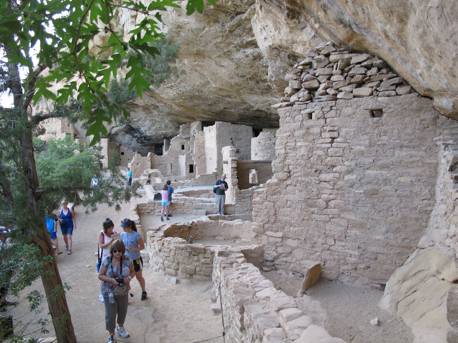
We chose the morning for this tour since the cliff dwelling was in the cool shade. Our guide explained life for the Ancestral Puebloans. These ancient peoples are sometimes called the Anasazi, but that is actually a Navajo word meaning “Enemy Ancestors.” So the A.P. name is preferred among the P.C. These people lived in the four corners area and up on the mesa from 750 A.D. until they quickly left Mesa Verde some time around 1250 A.D. for reasons still really unknown. They abandoned these marvelous cliff dwellings and they have survived to this day, a testament of these early people’s technical skills.
We focused on the Indian’s diet and nutritional needs as well as the hard life they lived farming corn on the top of the mesa and climbing up and down the vertical canyon walls to their homes.

We returned to our inn for lunch and then drove the windy forty-five minute journey to the less visited Wetherhill mesa where we toured the Long House and viewed other ancient dwellings including the Kodak House named because Wetherhill’s early exploring party stored their camera film in on of the rooms and the name stuck. Our tour guide for the Long House was very informative and the 90-minute tour added much to my knowledge of these early Indian cultures.
Later on our journey, I remarked to Linda how these trips just increase my thirst for knowledge. There is so much to learn: geology and geography, the flora and fauna, ancient history and modern history, about mountains and rivers and valleys. I could spend several lifetimes in books and school learning of the things I see. Travel is the ultimate pleasure for the mind and body, and an opportunity to enjoy time with loved ones in isolation and away from the daily habits. I’m already planning the next trip and it will be in just a few short days.
After that long day of tramping and sweating in the sun and heat, we returned to our rooms in the early evening and had a simple snack at the cafeteria before retiring for a well-earned rest. The Inn at Far View has no televisions, and I found the Internet access so busy I could not log in. Since the night sky was relatively cloudless, I pursued one of my goals for the trip.

That goal was to photograph the Milky Way. That’s our own galaxy, and it presents a band of barely visible stars across the sky, but the ever-present lights of civilization usually obscure the view. Here on top of the mesa, away from cities and people, the view should be better. I knew it was not a good date for galaxy viewing since the moon was in half lighted state, but I spent over an hour on our balcony accustoming my eyes to the low light and looking just below and to the left of Sagittarius trying to view the reclusive astronomical sight. It was not to be.
Perhaps in the middle of July while visiting Montana I can get on top of the Judith Mountain at the location of the dismantled 694th Radar Squadron base near Lewistown. The 15th of July will be a dark moon, and, if the Montana skies cooperate, I’ll capture that elusive view yet.
Although Linda and I were comfortably tired after scrambling up and down slopes all day, we spent a quiet hour of hand-holding on the balcony watching a lighting storm march across the horizon and enjoying the peace and solitude from the Far View Inn.

On Friday morning we packed up and headed down off the mesa, driving over to Cortez to fill the tank of car and body, scrape off some bugs, fill the ice chest with cool drinks, and head up the San Juan Skyway. On our return from Las Vegas a week previous, we took U.S. 550 over some of the most beautiful and awe inspiring mountain roads in all of Colorado. This time we chose to follow the Delores river and Colorado 145 up to Telluride.
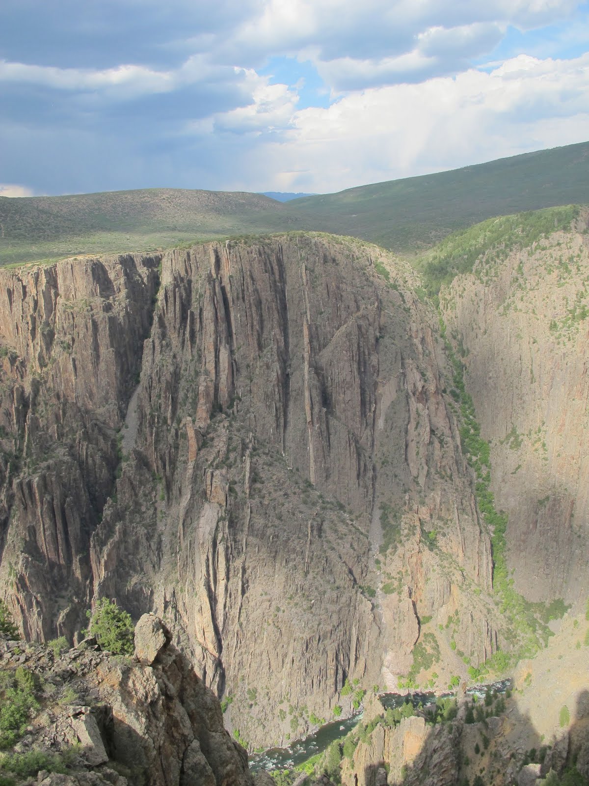
After lunch in a shady park in the former mining and now yuppie ski town, we continued north to Montrose. A short, late afternoon side trip to the Black Canyon of the Gunnison National Park where we viewed Colorado’s miniature Grand Canyon, it was on to our evening rendezvous with our great friend and Godson, Brenden, at his motel in Grand Junction.
We enjoyed a meal and conversation at the local Chili’s and then spent the night. We intended to stay at our friend’s motel, but he had double-booked some rooms and it was “no vacancy,” so we stayed at the Ramada Inn instead. I did some tech-support work, installing his printer and working on his motel’s wireless system before we called it an evening.

On Saturday morning we returned to Brenden’s for goodbyes, pictures, and a check on the wireless operation. We then headed up to the Colorado National Monument for a drive through more Colorado canyon land. After a couple of hours in that national parkland, we headed west on I-70 following the Colorado River to Rifle. There we turned north on Colorado 13. I don’t think we’ve ever driven that road before, and the change in scenery and geography lent itself to our enjoyment of the ranch land spread out between the bluffs. We reached Craig and turned east on US 40 for Hayden and our goal of Steamboat Springs.

We arrive early at Steamboat and checked into a lodge. From there it was on to downtown for a leisurely stroll and some fine mountain pizza at Beau Jo’s. We then walked the town until fatigue drew us back to the most comfortable bed we had enjoyed on the whole trip.
Sunday morning I arose early, but with reluctance, since we had to get back to Longmont in time for me to do my homeless outreach volunteer time. I work with HOPE driving an outreach van and providing meals and clothing to people in need. This trip was bookended between my HOPE shift on the previous Monday night and my shift on Sunday. We’ve been providing nearly one hundred meals to people on the streets, but that story is for another time.
To get back to Longmont from Steamboat Springs, there are only three ways “through the mountains.” You can go south to I-70 and cross over there. You can take Trail Ridge Road through Rocky Mountain National Park. Or you can drive the Poudre Canyon coming out near Ft. Collins.
I thought the drive through the Park might be very slow since it was a Sunday and the traffic can be like rush hour, and I had a deadline with my HOPE shift starting at 5:30 PM. I knew the fire north of Ft. Collins was in mop-up, and so we chose the highway 14 route through the Poudre Canyon.
There were many signs of the fire and also warnings not to stop. They didn’t want to take a chance on a new fire starting. We were looking for a place to stop and picnic, and we passed over a dozen beautiful picnic areas and campgrounds, but all were closed. There were police and soldiers guarding the side roads and blackened hillsides all around.
Fortunately, most of the man-made structures and homes along the river had survived. We saw one burned down house on the entire trip, but the heart of the fire was 10 miles north of this canyon in the Red Feathers region where over one hundred homes and cabins were lost.
We finally found a sunny picnic stop at the end of the canyon; ate lunch; and arrive home around 2:00 PM.

Although we didn’t go through Rocky Mountain National Park, part of Colorado Highway 14 is actually in the park, so technically I went to three national parks on this trip, plus a national monument. We had intended to go north from Grand Junction and visit Dinosaur National Monument too, but I modified the route and we’ll have to visit Dinosaur on another day. I’m also looking at a trip through Utah that would visit five national parks -- six if we go down to the Grand Canyon.
One advantage of being an old dude, is I have a card giving me free entrance to any national park and monument. That sort of makes up for the sore bones from the walking up and down mountain trails.

So that is the end of one of the most enjoyable and relaxing trips Linda and I have taken in the blue bus. She performed perfectly on this trip … the bus, not Linda, although she (Linda) was fine too. The peace and quiet and beauty of nature combined with the companionship of my beloved sweetheart is a great joy of retirement. This morning I got nervous when Linda had to go to the store for milk. Being retired means never having to leave her side.
During my HOPE tour last night, my partner who is a young engineer at Seagate, asked me if I was having a hard time with retirement. He said he had heard some people have difficulty adjusting and just don’t know what to do with all the free time. I told him I wasn’t having any problems, and we were busier than when I was working. But retirement allows me to spend all my time with Linda, and that is a blessing above all others. We will happily continue our touring until the wheels fall off the blue bus. So, until next time, I bid you gentle readers au-revoir, and see you next time.

This Is An Excellent Post I Seen. I Have To Thanks To You To Share It It Is Really What I Wanted To See Hope In Future You Will Continue For Sharing Denver to Steamboat Springs Transportation
ReplyDelete